ARMENIAN LAND
Armenia with 5 thousand years of civilization is one
of the human cradles in the world. Indo-European Armenians had developed
an exemplary high culture. Here the first statehoods had been established
yet in the early third millennium BC and were the contemporaries of Schumer,
Accad and Ancient Egypt ones. In ancient descriptions the Armenia was
considered as a "Sacred Highland". With reference to the Bible
the humanity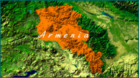 had been created right here in the paradise-on-land laid at the beginning
of Euphrates and Tigris rivers. Here is the mountain Ararat, which carried
the Noah's Ark. For an Ancient world Armenia had been considered as a
provider of material and human ideological resources. Some great discoveries,
which considerably promoted the development of the humanity, had been
made here. The Armenian Highland is considered the pre-homeland of the
Indo-European peoples as well. Armenians are among these nations with
an ancient manuscript. According to the tradition Armenian's Forefather
Hayk was the inheritors of the Noah's son Habet. The first Pan-Armenian
state was established in 4th century BC and till the end of the 4th century
after Christ Armenia had been considering among the three most powerful
states of the Ancient world and during this period twice managed reaching
the regional superiority.
had been created right here in the paradise-on-land laid at the beginning
of Euphrates and Tigris rivers. Here is the mountain Ararat, which carried
the Noah's Ark. For an Ancient world Armenia had been considered as a
provider of material and human ideological resources. Some great discoveries,
which considerably promoted the development of the humanity, had been
made here. The Armenian Highland is considered the pre-homeland of the
Indo-European peoples as well. Armenians are among these nations with
an ancient manuscript. According to the tradition Armenian's Forefather
Hayk was the inheritors of the Noah's son Habet. The first Pan-Armenian
state was established in 4th century BC and till the end of the 4th century
after Christ Armenia had been considering among the three most powerful
states of the Ancient world and during this period twice managed reaching
the regional superiority.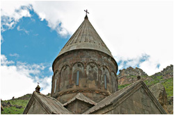 Nowadays Armenia covers the only 1/10 part of the Armenian Highland area
The Major Armenia covered more than 300.000 square kilometers reaching
the Asia Minor at the West, Northern Mesopotamia at the South, almost
to the Black Sea at the North and the Caspian Sea at the East.
In the eastern part of the Asia Minor was developing another Armenian
state described in the ancient sources as Minor Armenia. In 301 Armenia,
first among other nations adopted the Christianity as a State religion.
In 387 the Romans and Persia divided the Armenia between each other.
In 428 Armenia regained its independence. After some 450 years of struggle
Armenia again regained its independence, but which exterminated in 1045
by Byzantium. In the late 11th century an Armenian statehood was established
in Kilikia, and its commander Levon was inaugurated as a King in 1198.
The Armenian Kingdom in Kilikia was a European-type state with a rich
culture and traditions. It survived till 1375. About 8 and half centuries
the Armenians were in the composition of Turkish, Persian and then Tsarist
Russian empires. In 1918 the first Republic of Armenia was formed, which
further in 1920 turned to the Soviet Armenia.
In 1991 Armenia regained its independence creating the third republic.
In the same year another Armenian State Kharabagh proclaimed its independence,
too.
Armenians are among unique nations in the world, who have got great glory,
suffered foreign yoke for centuries, genocide and renaissance without
losing their national identity, proud, creativity and aspirations towards
the happy future.
SYUNIK
Syunik is one of the most ancient regions in the world.
As of Stone Age period the region had all the time been inhabited. In
mediaeval centuries the Syunik governors had the biggest army among other
Armenian local authorities and managed to establish statehood as well
(10-11th centuries). 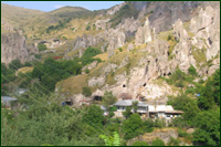 The
Syunik land preserved its semi-independent state till the new stage and
in the early 19th century was included in the composition of the Russian
empire and in 1920-1921 heroically run self-defense against the Bolshevik
invaders. The name Syunik had been derived from the name of the ancient
Armenian pagan God Sivini. According to the tradition, the Syunik-Sisakan,
as well as town Sisian bears the name of the Hayk forefather's grandson
Sisak.
The
Syunik land preserved its semi-independent state till the new stage and
in the early 19th century was included in the composition of the Russian
empire and in 1920-1921 heroically run self-defense against the Bolshevik
invaders. The name Syunik had been derived from the name of the ancient
Armenian pagan God Sivini. According to the tradition, the Syunik-Sisakan,
as well as town Sisian bears the name of the Hayk forefather's grandson
Sisak.
In the past the region, together with its lands, included the following
territories of the nowadays Armenia - Vayots Tsor and Gegharkunik regions
with nearby territories. Today, the center of the region is town Kapan.
The other towns are Sisian, Goris, Mexri and Qajaran.
Syunik is distinguished with its calm mountainous climate, fresh air,
cold water sources, rivers and lakes, natural riches, resort houses, historic
and cultural monuments. Today the region has commenced its modern time
development stage preserving the unique features of its traditional culture.
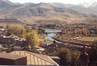
SISIAN
: RA Syunik region's Sisian sub-region with the town
of the same name was the biggest sub-region of the former Soviet Armenia
(1719 square km). Town Sisian is situated 217 km far from Yerevan, 6-7
km to the South from Yerevan-Kharabagh and Yerevan-Iran highway. It is
located on both banks of the Vorotan River, 1600 meters above sea level.
The average temperature in January is -5 C and 17.9 C in July.
In mediaeval centuries the town Sisian beard first Syuni and then, in
1935-1940 Sisakan names.
As a historic-geographic territory it has permanently been included in
the composition of Major Armenia's Syunik or Sisakan regions and from
the beginning has been the administrative-political and religious center
of both its forefathers and governing dynasties. Nowadays Sisian sub-region
mainly includes the territory of the Tsxuk land of the historic Syunik
region. In written sources the Tsxuk land first is mentioned in 8th B.C.
According to the tradition the Sisakan-Syunik was the estate of the Hayk's
grandson Sisak and to this end beards his name. In pagan period Sisakan
was the one of considerable centers of Sun worship.
The name §Syunik¦ comes from the name of the Urartu's God
of the Sun Sivini-Shivini and the Sisakan-Sisian, by all probabilities
comes from the Schumer sisi, sisu (horse), which was considered the symbol
of Sun worship at that time. The most ancient monuments of the Sisian
are dated as of Stone Age period. Among the most famous and valuable pre-Christian
monuments are the Uxtasar's rock images (5-2 millennium B.C.) and Zorats
Qarer Megalith monument and Uyts Megalith settlement (both are dated 3-1
millenium B. C.). There are numerous partly revealed and studied and non-studied
shrines, fortresses and mausoleums.
 The stone inscription of the king Argishti the Second (8th century B.C.),
one of Artashesi borderline stones (2nd century B.C.) and many other treasures
have been found from the Sisian's territory. Among Christian stage historic-architectural
monuments are famous the Tanahat's church (4-5th centuries), Syuni church
(6-7th centuries), Aghitu monument (6-7th centuries), Vorotnavank (first
mentioned in 4th century), Vorotnaberd (mentioned in 5th century) and
many other monuments as well.
The stone inscription of the king Argishti the Second (8th century B.C.),
one of Artashesi borderline stones (2nd century B.C.) and many other treasures
have been found from the Sisian's territory. Among Christian stage historic-architectural
monuments are famous the Tanahat's church (4-5th centuries), Syuni church
(6-7th centuries), Aghitu monument (6-7th centuries), Vorotnavank (first
mentioned in 4th century), Vorotnaberd (mentioned in 5th century) and
many other monuments as well.
The Sisian's sub-region is distinguished by its sightseeing, among them
the Shake's waterfall, Vorotan's gorge, mountainous lakes and reservoirs.
In Sisian various cultural centers function, where both the past historic
heritage and the nowadays-cultural values of both Syunik region and town
Sisian are represented.
The Sisian's state museum of History after N. Adonts is distinguished
by its rich historic-archeological and ethnographic exemplars, as well
as by Qaradaran with rich collection of stone monuments.
The branch of the RoA National Gallery functions as well, where one may
be introduced with the art crafts of both Armenian famous and local artists.
Various places for leisure are available in the town as well.
SIGHTSEEING
UXTASAR'S ROCK IMAGES
Uxtasar's rock images are situated about 25 km North
to the Sisian, at the central part of the Syunik Highland, in the site
between Black and Al lakes 3300 meters above sea level. The road to this
monument is almost impassable and available only during June-September.
 These rock testimonies of Armenian forefathers are approximately dated
5-2 millenium B.C. These are carved on more than a thousand laid stones
and depicted people at hunting, working, worshipping. There are depictions
of domestic and wild animals, terrestrial bodies, cosmic and other suchlike
images. There are many inexpressible outlines as well. The rock images
are the prototypes of
These rock testimonies of Armenian forefathers are approximately dated
5-2 millenium B.C. These are carved on more than a thousand laid stones
and depicted people at hunting, working, worshipping. There are depictions
of domestic and wild animals, terrestrial bodies, cosmic and other suchlike
images. There are many inexpressible outlines as well. The rock images
are the prototypes of 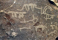 manuscripts,
which pass the whole and completed events through interrelated images
and enable us to reveal the ancient people's living, worldview and skills.
manuscripts,
which pass the whole and completed events through interrelated images
and enable us to reveal the ancient people's living, worldview and skills.
Uxtasar's rock images are of worldwide importance monuments, which reveal
the cultural sources of Armenian nation. It is one of the loveliest sightseeing
for tourists. During past 8-9 years many tourists have reached this almost
impassable site end enjoyed both the archaic stone images and the picturesque
surrounding with cold water sources.
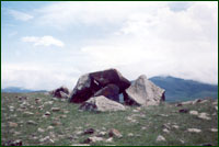
ZORATS QARER
(Armenian Stonehedge)
Zorats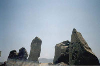 Qarer is in the spotlight of the tourists conditioned by its high historic-cultural
value and easy-to-reach geographical position. It is located near the
Yerevan-Iran and Yerevan-Mountainous Kharabagh highway, in the Sisian's
part, 300-400 meters far from the highway and distinguished by the nearby
fascinating nature as well.
Qarer is in the spotlight of the tourists conditioned by its high historic-cultural
value and easy-to-reach geographical position. It is located near the
Yerevan-Iran and Yerevan-Mountainous Kharabagh highway, in the Sisian's
part, 300-400 meters far from the highway and distinguished by the nearby
fascinating nature as well.
Zorats Qarer Megalith monument famous also as “Armenian Stone Hedge”,
Qarahunj and with other names and situated 3 km north to the Sisian. Having
a unique structure in its kind, it has not fully studied yet. The monument
is a complex of hundreds of vertically fixed stones covering more than
three hectares area. It is 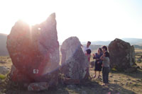 1770
meters above sea level. The all stones of the monument are of basalt and
on some of them there are hauls. The main disputes in scientific circles
about this structure are framed within two viewpoints.
1770
meters above sea level. The all stones of the monument are of basalt and
on some of them there are hauls. The main disputes in scientific circles
about this structure are framed within two viewpoints.
First version states that the vertically fixed stones are religious monuments/menhirs
devoted to the deceases, the central oval structure is a kromlex and the
hauls opened on stones have a technical meaning.
The second version states that the Zorats Qarer is an ancient observatory
designed for the observation of terrestrial bodies and time setting and
the hauls on stones are designed to more precisely observe these terrestrial
bodies from different poses. Due to this version the Zorats Qarer has
been juxtaposed with the English Stone Hedge, French Karnak, Dutch new
Grege which are considered as Sun worshipping centers and observatories.
Based on archeological data the archeologists suppose the Zorats Qarer
had built in 3-2 millenium BC during the transitional stage from the early
Bronze to the Medium Bronze period and survived till the middle of the
1st millenium. Some astrologists, based on new facts, suppose that it
is 6000 or 8000 years old.
UYTS MEGALITH SETTLEMENT
 It
is situated on the eastern borders of Sisian, in front of the Syuni fortress,
on the right-hand high area of the Vorotan's gorge nearby to the village
Uyts. This amazing monument has not almost been studied and its partial
studies and geometrical calculations have brought to the initial conclusions
that from Uyts to the Aghitu village area (about 2 km) a great ancient
city had existed, which had permanently survived from the third millenium
to the middle of the first millenium. Many Cyclopean structures: dolmens,
kromlexs and walls like Zorats Qarer have been preserved. This monument
excesses by its sizes not only the suchlike monuments of the Armenia dated
at that time, but also the regional ones. The local population calls it
Sangyar-Qaraberd.
It
is situated on the eastern borders of Sisian, in front of the Syuni fortress,
on the right-hand high area of the Vorotan's gorge nearby to the village
Uyts. This amazing monument has not almost been studied and its partial
studies and geometrical calculations have brought to the initial conclusions
that from Uyts to the Aghitu village area (about 2 km) a great ancient
city had existed, which had permanently survived from the third millenium
to the middle of the first millenium. Many Cyclopean structures: dolmens,
kromlexs and walls like Zorats Qarer have been preserved. This monument
excesses by its sizes not only the suchlike monuments of the Armenia dated
at that time, but also the regional ones. The local population calls it
Sangyar-Qaraberd.
HOVVI QAR/SHEPERD'S STONE
The monument is situated 8 km south to the Sisian nearby to village Brnakot.
It is an ancient settlement built by menhirs with circled soaring walls.
Its central part is an altar. The monument has not studied yet, but obviously
it is a megalith structure like Zorats Qarer and Qaraberd. Suchlike kromlexs
are available in the Sisian's mausoleums as well and one may also meet
alike monuments in the Western Europe, where they are counted about 900.
SYUNI CHURCH
It is situated in the west-north part of town Sisian, on a hill and has
alternative names as well: St. Grigor Lusavorich, St. Hovhannes, and Sisavan.
Syuni church, which was the third biggest church after Tatev and Tanahat
and named after St. Grigor Lusavorich have been built by the great benefactor
Syunik's Mrs. Varazduxt after in 520-530 BC. Syuni church like the majority
of ancient Armenian churches has been built on the bases of the pagan
temple.
The palace and court of Syunik's governors have been located in the front
square of the church. Perhaps in the place of the ancient Syuni (Sun)
pagan temple the St. Grigor Lusavorich church has been built and in the
late 7th century renamed St. Hovhannes.
Syuni church is made of basalt, on a three-level deck. According to its
draft, it belongs to the Avan-Hripsime-typed churches and distinguished
by its archaic structure. Within the range of its dome's small tromps
are inserted the sculptures of its re-builders: Kohazat governor, Hovsep
the A and Teodoros monk with respective inscriptions. There are numerous
stone images and inscriptions on its walls including stone carvings. Many
khachkars are available in its territory. The main reconstruction of the
church was implemented in 1959-1961. The church has been re-commenced
its operations since 1979
:
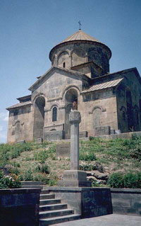
VOROTNAVANK
It is situated 14 km east to the Sisian on the left-hand
hill of the Vorotan's gorge.
Vorotnavank is mentioned still from 4th century. Nowadays preserved buildings
have been built by the Syunik's queen Shahanduxt in 1000, who was the
grandmother of Katramide wife of the Armenian king Ashot the Yerkat, 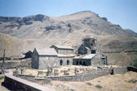
mother of the Syunik's governor Vasak the A and the wife of Smbat the
A. Formerly in the place of the Vorotnavank was the Christian shrine after
St. Grigor Lusavorich/Gregory the Illuminator. The inscription on its
establishment has been preserved “In 1000 Shanaduxt by order of
king Smbat built a church after St. Naxavka Stepanos, then in 1006 Sevada,
the brother of king Vasak built here a church after St. Karapet and its
chapel”.
Shahanduxt built also art centers and wholesale houses surrounded them
with defending walls. A pillar was erected in its yard, which meant that
monks were being entered into religious service here and governors inaugurated.
In 1104 the Vorotnavank was destroyed by Seljuks and afterwards was rehabilitated
during the reign of Orbelyan family. Stone inscriptions by local governors
have preserved on its stones (14th century). Here the mediaeval great
Armenian philosopher Hovhan Vorotnetsi (1315-1388) runs his religious
and scientific activities. He had established close ties between Vorotnavank
and Tatev establishing the Tatev's university. During the Lank-Temurs
invasions the church had destroyed again. In the late 19th century the
church was in a poor condition. In 1931 the church was entirely destroyed
by the earthquake and only in 1980 the reconstruction works of the church
were commenced.
TANAHAT CHURCH
This ancient church is situated 17 km south-west to the
Sisisan. It has been titled Red Church, because was made of red stones.
The church has been built in the place of the pagan temple devoted to
the Armenian she-God Anahit. 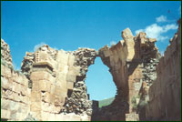 In
5th century here a Christian church was built with a beautiful range of
stone lilies. The range of columns is located in its eastern side. The
early mediaeval cemetery surrounds the church. The stone inscription of
Armenian king Argishti the First (8th century B.C.) has been excavated
here. The name of the Tsxuk land of the Syunik region had first time been
mentioned, which borders are almost coincide with the nowadays Sisian
sub-region. Tanahat church had functioned till the late mediaeval ages.
Today it is in a destroyed condition and the reconstruction activities
are envisaged.
In
5th century here a Christian church was built with a beautiful range of
stone lilies. The range of columns is located in its eastern side. The
early mediaeval cemetery surrounds the church. The stone inscription of
Armenian king Argishti the First (8th century B.C.) has been excavated
here. The name of the Tsxuk land of the Syunik region had first time been
mentioned, which borders are almost coincide with the nowadays Sisian
sub-region. Tanahat church had functioned till the late mediaeval ages.
Today it is in a destroyed condition and the reconstruction activities
are envisaged.
TATEV MONASTERY
The famous monument of the Armenian mediaeval architecture
the Tatev's church complex is situated 35 km to the south of Sisian, nearby
to the village Tatev. Since 8th century it had become the seat of the
Syunik's diocese. 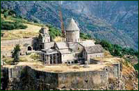 In
906 the cathedral of the monastery titled Poghos Petros was built, in
1067 the St. Astvatsatsin mausoleum -church, in 1295 the St. Grigor church.
In 1390-1435 the famous Tatev's mediaeval university and school of miniature
and manuscript were functioning.
In
906 the cathedral of the monastery titled Poghos Petros was built, in
1067 the St. Astvatsatsin mausoleum -church, in 1295 the St. Grigor church.
In 1390-1435 the famous Tatev's mediaeval university and school of miniature
and manuscript were functioning.
The monastery had a great matenadaran, where more than 10 thousand manuscripts
were kept. Here is the tombstone of the prominent Armenian philosopher
and theologian Grigor Tatevatsi. Tatev is famous also by its khachkar-beard
rod, which is considered as one of the interesting Armenian architectural
solutions.
In 20th of the 17th and 20th centuries it was an important freedom-fighting
spot. Many occurrences are connected with the monastery. At the end of
the 20th century some construction and rehabilitation works have been
carried out in the territory of the monastery. Now the monastery is functioning
and the spiritual center of the Syunik's diocese.
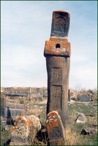
AGHITU MONUMENT
It is one of the most famous ancient Syunik settlements
and situated 7 km east to the Sisian on a circled hill on the left bank
of the Vorotan River. Aghitu is considered as one of the first religious,
military and influential settlements of the Syunik region.
Aghitu is famous by its prominent graveside bust-monument built in 6th
or 7th centuries. The monument is a three-stored structure with two roaring
columns and the central 8-sided pillar is completed with a circled stone
image.
Three columns symbolizing the Holy Trinity are roaring above them. 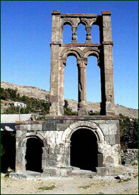 The
sculptures on the monument are resembled the sculptures of the St. Grigor
Lusavorich and Zvartnots churches. Stone inscriptions are available on
it as well. This monument, together with Otsun's one is considered as
a unique and memorial. It is worth mentioning that the columns of the
Sardarapat memorial are copied from this monument-graveside bust. The
meaning of the Aghitu monument is controversial among the scientific circles.
According to the national legend here two martyred brothers are rested
upon. One of the versions states that here is the tomb of the people martyred
for their Christian belief. Another version based on archaeological excavations
states that it was a part of the great complex with a church next to it
(10-11th centuries) and other monumental structures. Indeed, beneath the
monument early mediaeval tombs have been excavated. The monument refers
to the martyrs of the Avarayr Battle as well and the graveside bust have
erected in the sake of these martyred people. The name of the village
(Aghxitu-Aghitu) prompts us that it was the agh-estate of the Syunik's
governors and there is another version as well that it is their family
cemetery. There is a version that it have been erected based on the collective
funeral action of died fighters as Romans do. Two basalt-made sculptures
and the other excavated materials from the monument are preserved in the
Sisian's museum of the history.
The
sculptures on the monument are resembled the sculptures of the St. Grigor
Lusavorich and Zvartnots churches. Stone inscriptions are available on
it as well. This monument, together with Otsun's one is considered as
a unique and memorial. It is worth mentioning that the columns of the
Sardarapat memorial are copied from this monument-graveside bust. The
meaning of the Aghitu monument is controversial among the scientific circles.
According to the national legend here two martyred brothers are rested
upon. One of the versions states that here is the tomb of the people martyred
for their Christian belief. Another version based on archaeological excavations
states that it was a part of the great complex with a church next to it
(10-11th centuries) and other monumental structures. Indeed, beneath the
monument early mediaeval tombs have been excavated. The monument refers
to the martyrs of the Avarayr Battle as well and the graveside bust have
erected in the sake of these martyred people. The name of the village
(Aghxitu-Aghitu) prompts us that it was the agh-estate of the Syunik's
governors and there is another version as well that it is their family
cemetery. There is a version that it have been erected based on the collective
funeral action of died fighters as Romans do. Two basalt-made sculptures
and the other excavated materials from the monument are preserved in the
Sisian's museum of the history.
MELIK TANG'S BRIDGE
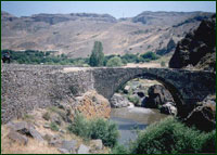
The bridge is located 20 km to the east from Sisian. It has been built in 1855 on the Vorotan River, in the vicinity of the ancient Vorotn village (Melik's village) by the Syunik Melik Tang. The stones for its construction have been taken from the nearby destroyed church and cemetery of an earlier stage. The bridge is beneath the Vorotnavank's carves, which increases the beauty of the bridge.
VOROTNABERD
It is situated 20 km east to the Sisian and mentioned
from 4th century. It was one of famous and powerful fortresses
of the Syunik. In 1104 Seljuks held the Vorotnaberd. In 1211 the Zaqaryans
(Armenian governors) emancipated it and give it to the famous Armenian
leading family: Orbelyans. In 1236 Lank-Temur army held the fortress.
Then the Vorotnaberd was mentioned in 1724 concerning the freedom-fighting
run by Davit Bek and entered the people's memory as a fortress of Davit
Bek. Now the walls of the citadel and the tombstones of Orbelyans have
been preserved.
Their beauty distinguishes the fortress and its vicinity. Vorotnaberd
and Vorotnavank are situated on both banks of the Vorotan River and had
been connected to each other via underground viaduct, which was successfully
being used during alien sieges.
SHAKE WATERFALL
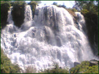
It is located in the Vorotan's gorge, 3 km far from Sisian,
on the Shake confluent: left bank of the Vorotan River. Its height is
18 meters. Shake is the highest and the most beautiful waterfall of Armenia
and, as a place of sightseeing, permanently hosts tourists and visitors.
Its distance from Yerevan-Kharabgh highway is 4 km.
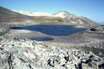
RESERVOIRS
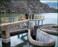 Sisian's
sub-region is famous by its water resources. Here one may find both natural
mountainous lakes and reservoirs. By their size the Spandaryan, Tolors
and Shamb reservoir is distinguished, which are good places for fishing,
swimming and leisure in general. The half-drawn church of the Ashotavan
village is in the Tolors reservoir. Surprisingly, for many years it is
not destroyed being under the water. The Shamb reservoir is famous by
its Edelweiss construction.
Sisian's
sub-region is famous by its water resources. Here one may find both natural
mountainous lakes and reservoirs. By their size the Spandaryan, Tolors
and Shamb reservoir is distinguished, which are good places for fishing,
swimming and leisure in general. The half-drawn church of the Ashotavan
village is in the Tolors reservoir. Surprisingly, for many years it is
not destroyed being under the water. The Shamb reservoir is famous by
its Edelweiss construction.
![]()
FAMOUS VILLAGES
ANGEGHAKOT
 Angeghakot
is 17 km far from Sisian. It is one of famous and ancient villages of
the Syunik region. It may be called “a museum in the open air”.
Out of 7 churches of the village two are yet standing: nearby to the village
is the famous mediaeval cemetery with ancient khachkars and one may face
many stone monuments in the village as well. Nearby to the village is
the shrine of the Vardan the Commander, where, according to the tradition
is rested upon Vardan Mamikonyan. Angeghakot connects with many important
events. It was a famous Melik Center and in 1699 here the prominent Armenian
diplomat Israyel Ori convened the famous meeting with the Syunik Melik
(local governors). Village was a spotlight during 1918-1919 and 1920-1921
freedom-fighting. In 2005-2006 Armenian and foreign archeologists have
excavated a famous ancient settlement, which, according to experts' estimations,
may date 6-4 millenium BC and refers to the Mesopotamian Neolithic culture.
The excavations are on.
Angeghakot
is 17 km far from Sisian. It is one of famous and ancient villages of
the Syunik region. It may be called “a museum in the open air”.
Out of 7 churches of the village two are yet standing: nearby to the village
is the famous mediaeval cemetery with ancient khachkars and one may face
many stone monuments in the village as well. Nearby to the village is
the shrine of the Vardan the Commander, where, according to the tradition
is rested upon Vardan Mamikonyan. Angeghakot connects with many important
events. It was a famous Melik Center and in 1699 here the prominent Armenian
diplomat Israyel Ori convened the famous meeting with the Syunik Melik
(local governors). Village was a spotlight during 1918-1919 and 1920-1921
freedom-fighting. In 2005-2006 Armenian and foreign archeologists have
excavated a famous ancient settlement, which, according to experts' estimations,
may date 6-4 millenium BC and refers to the Mesopotamian Neolithic culture.
The excavations are on.
BRNAKOT
Brnakot is situated 7 km far from Sisian. It was one
of the famous Melik (local governors) centers of the Syunik.
The village is famous both by its monuments, church and its famous representatives/villagers.
It is the birthplace of the prominent Armenian historic Nikoghayos Adonts.
Four heroes of the Great Patriotic War, many scientists, artists and state
activists are from the village as well. Megalith monument titled “Hovvi
Qar/Shepherd's Stone- is nearby to the village.
LOR
Lor is a famous ancient settlement. First time it had been mentioned in 839. Here the Cross-statute-monument titled White or Loriki Khach built in 1271 is situated erected by governor Vorotshah in memory of his parents. Lor was a famous mediaeval educational and manuscript center. There are a number of manuscripts in the Matenadaran taken from or authorized by Lor. The school built in 1905 is still operable. In 1915-1916 the famous Armenian writer Aksel Bakounts was a teacher in Lor and his story "Xonarh Axchikw/Humble Girl" had been written at that period. Lor is the birthplace of the famous Armenian poet Hamo Sahyan leaving an indelible mark on his insight and literal heritage.
The village is situated in a very beautiful place 26 km far from Sisian.
![]()
CULTURAL CENTERS
SISIAN'S MUSEUM OF HISTORY AFTER N. ADONTS
Sisian's museum of History after N. Adonts has been established
in 1990. The museum has a rich collection of historic-archeological and
ethnological materials highlighting the history of both Sisian and Syunik
region: in line with permanent exhibitions 2-3 temporary exhibitions are
organized annually as well. The material values raised during archeological
excavations and studies in the region are collected and preserved in the
museum (mausoleum-field from Zorats Qarer, Aghitu and Syuni fortress etc.),
numerous occasional findings, 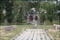 rich
collection of Syunik's hand-woven rugs and many other historic and cultural
values.
rich
collection of Syunik's hand-woven rugs and many other historic and cultural
values.
Museum has also a Qaradaran with a rich collection of
ancient stone monuments (more than 45 exemplars are represented - stone
images, tombstones, khachkars, sarcophagi etc.). It is a lovely place
for tourists and visitors of the town
SISIAN'S BRANCH OF RoA NATIONAL GALLERY
It has been established in 1978. During 1993-1998 it
has been functioning within the composition of the Museum of History after
N. Adonts and since 1998 as a branch of the RoA National Gallery. 
Three types of art crafts are exhibited at the Gallery: water-colour, graphics and sculpture. The masterpieces of the famous Armenian artists of late nineteenth and early twentieth centuries (M. Saryan, P. Terlemezyan, A. Kalunts, S. Arakelyan, E. Isabekyan, H. Hakobyan, H. Hmayakyan, H. Zardaryan, G. Xanjyan, S. Baghdasaryan, S. Manasyan, H. Gyurjyan, V. Ayvazyan, M. Abefgyan, A. Gharibyan etc.) are demonstrated here. Exhibitions of local artists are organized in the gallery as well.
The building of the gallery repaired in 1988. It is a lovely place for tourists and visitors.
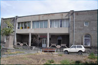
FINE ART SCHOOL
Sisian's art school has been established yet in the
Soviet times as a vocational school for fine painting.
Here the community's school-age children are studied; who continue their
education in various national vocational and high art schools and institutions.
The school has many skilled alumni. Here it is conducted not only educational
activities, but also organized exhibitions and other cultural events.
Thanks to efforts of the school's staff one may be introduced with the
paintings of its skilled pupils and alumni, as well as to buy them.
The school's staff greatly contributes into the development of tourism
business in the region as well. The school hosts the Sisian's information
center for tourism development.
![]()
Copyright
![]() "LALANER
"LLC; Designed by INFOELECTRON
LLC
"LALANER
"LLC; Designed by INFOELECTRON
LLC